
A River Ran Through It

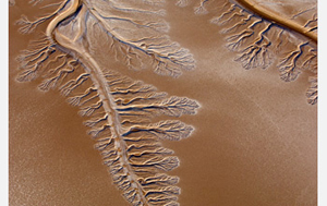
About the image: A now dry Colorado River delta branches into the Baja/Sonoran Desert near the Sea of Cortez. Image credit: Pete McBride
Rivers and streams supply the lifeblood to ecosystems across the globe, providing water for drinking and irrigation for humans as well as a wide array of life forms from single-celled organisms up to the fish humans eat.
But humans and nature itself are making it tough on rivers to continue in their central role to support fish species, according to new research by a team of scientists including John Sabo, a biologist at Arizona State University.
Globally, rivers and streams are being drained due to human use and climate change. These and other human impacts alter the natural variability of river flows.
Some affected rivers have dried and no longer run, while others have seen increases in the variability of flows due to storm floods. (more…)