
Honolulu, HI – The possible spread of the oil spill from the Deepwater Horizon rig over the course of one year was studied in a series of computer simulations by a team of researchers from the School of Ocean and Earth Science and Technology (SOEST) at the University of Hawaii at Manoa.
Eight million buoyant particles were released continuously from April 20 to September 17, 2010, at the location of the Deepwater Horizon oil rig.
The release occurred in ocean flow data from simulations conducted with the high-resolution Ocean General Circulation Model for the Earth Simulator (OFES).
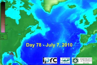
About the image above: This image shows the spread of the oil spill on Day 78 (July 7, 2010), based on simulation. Image credit: IPRC/SOEST/UHM
“From these 8 typical years, 5 were selected to create an animation for which the calculated extent of the spill best matches current observational estimates.”
The animation shows the calculated surface particle concentrations for grid boxes about 10-km-by-10-km in size into April 2011.
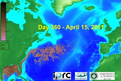
About the image above: This image shows the spread of the oil spill on Day 360 (April 15, 2011), based on simulation. Image credit: IPRC/SOEST/UHM
For an estimated flow of oil from the Deepwater Horizon of 50,000 barrels per day over a 150 day period, a concentration of e.g. 10 particles per grid box in the animation corresponds roughly to an oil volume of 2 cubic meters per 100 square kilometer.
The oil spreads initially in the Gulf of Mexico, then enters the Loop Current and the narrow Florida Current, and finally the Gulf Stream. “After one year, about 20% of the particles initially released at the Deepwater Horizon location have been transported through the Straits of Florida and into the open Atlantic,” explains Timmermann.

About the image above: This topographical map with a yellow bar shows the narrow section of the Straits of Florida that form a bottleneck for the Florida Current. Image credit: IPRC/SOEST/UHM
The narrow, deep Straits of Florida force the Florida Current into a narrow channel, creating a tight bottleneck for the spreading of oil into the Atlantic. As the animation suggests, a filtering system in the narrowest spot of the Florida Current could mitigate the spreading of the oil film into the North Atlantic.
This research was supported by the Japan Agency for Marine-Earth Science and Technology (JAMSTEC), NASA and NOAA through their sponsorship of the International Pacific Research Center in the School of Ocean and Earth Science and Technology at the University of Hawaii at Manoa.
*Source: University of Hawaii at Manoa