
The public is invited to help identify objects they see in images of the seafloor through a new interactive website called “Seafloor Explorer.” The result of a unique collaboration between oceanographers studying seafloor habitats, Web programmers and social scientists, Seafloor Explorer (www.seafloorexplorer.org) launches September 13.
The team has more than 40 million images, but are launching the site with a preliminary set of 100,000 – all of them taken by HabCam, a habitat mapping underwater vehicle. HabCam was developed and built by the HabCam group, which comprises marine biologists and engineers from the Woods Hole Oceanographic Institution (WHOI) as well as fishermen and other scientists. The Seafloor Explorer interactive website was funded by a grant from the Alfred P. Sloan Foundation, and built in collaboration with the HabCam Group by the Citizen Science Alliance (CSA), the developers behind interactive sites found on Zooniverse.org.
Public contributors to the website will say whether they see fish, scallops and other organisms in each image, provide basic measurements, and describe whether the seafloor is sand or gravel, and whether they see boulders and other interesting objects in the frame.

A unique collaboration between oceanographers studying seafloor habitats, Web programmers and social scientists has resulted in a new interactive website called “Seafloor Explorer,” which asks members of the public to help identify objects they see in images of the seafloor. Public contributors will say whether they see fish, scallops and other organisms in each image, provide basic measurements, and describe whether the seafloor is sand or gravel, and whether they see boulders and other interesting objects in the frame. (Image courtesy Seafloor Explorer/Zooniverse.org)
“We’re really excited about this project,” says Dr. Scott Gallager, a WHOI biologist in the HabCam Group and Principal Investigator of the Cooperative Institute for the North Atlantic Region National Oceanic and Atmospheric Administration project to develop the next generation HabCam imaging system, the first project to use the new annotation tool. “We’ll gain a greater understanding of organisms living on the seafloor and create maps of habitats at a resolution that we would not be able to do without this kind of help – because of the manpower required.”
Ultimately contributions by the public will help scientists answer questions about the distribution of scallops and other resources relative to their predators such as starfish and the composition of their habitat. Along the way, the contributors have a chance to enjoy working with seafloor imagery that has never been seen before, through a unique Web interface.
“There’s a lot of technology under the hood to make this a compelling user experience,” says Dr. Arfon Smith, director of Citizen Science at The Adler Planetarium, home of the Zooniverse websites.
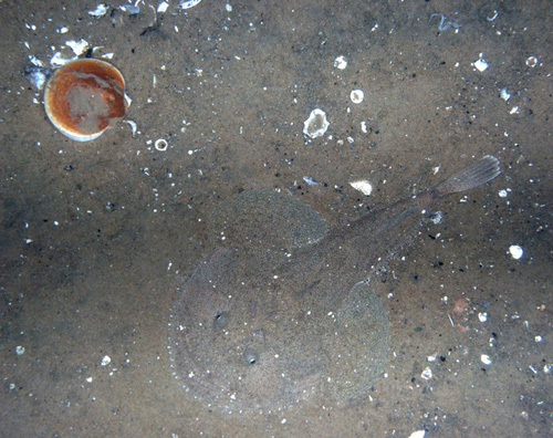
A sea scallop (Placopecten magellanicus) and a monkfish (Lophius americanus) captured on camera by the HabCam. Seafloor Explorer will launch with a preliminary set of 100,000 images from the more than 40 million images the HabCam team has. Public contributors to the website will say whether they see fish, scallops and other organisms in each image, provide basic measurements, and describe whether the seafloor is sand or gravel, and whether they see boulders and other interesting objects in the frame. (Photo courtesy HabCam Group, Woods Hole Oceanographic Institution)
The idea of using the public to provide analysis of scientific data is relatively new and is gaining acceptance in scientific circles. Over the past several years, CSA has developed the statistical context by which data extracted by citizens are interpreted. In that time, the CSA has used their technique in 14 projects such as Galaxy Zoo (www.galaxyzoo.org), Planet Hunters (www.planethunters.org), and Old Weather (www.oldweather.org), and the work has resulted in more than 40 peer-reviewed scientific papers.
“The website’s primary focus is to deliver on a real science goal that couldn’t be delivered in any other way or without significant financial resources,” says Smith. “With careful analysis of the data collected, the results are at least as good as what one would get from a professional. The method is somewhat radical, but the output is quite traditional.”
The HabCam team hopes the Seafloor Explorer website will add to the growing confidence of this kind of carefully monitored and administered citizen science. “CSA set a precedent and found a way to take crowd-sourced data and produce a valid scientific product,” says Amber York, a HabCam researcher in Gallager’s Lab.
The HabCam imagery used in this project was collected in coastal regions of the Northeast, including Georges Bank, the Mid-Atlantic Bight, and the Stellwagen Bank National Marine Sanctuary. To collect imagery, HabCam is towed from a ship and “flies” approximately 2.5 m (6-8 ft.) above the seafloor, collecting six to 10 images per second. Getting help going through the millions of images collected is one of the reasons the HabCam group reached out to the Citizen Science Alliance.

The HabCam team also hopes the Seafloor Explorer project will help them in efforts to develop automated classification of images. “We have the right tools now to do automated classification of say, scallops and substrate. But what we need are training sets,” says Amber York, left. “We need images that humans have identified and have said ‘Yes, that’s a scallop right there.’” Adds Scott Gallager, right: “Then our automated tools can use the human-annotated training sets to identify scallops in images humans haven’t looked at yet.” (Photo by Tom Kleindinst, Woods Hole Oceanographic Institution)
The team also hopes the Seafloor Explorer project will help them in efforts to develop automated classification of images.
“We have the right tools now to do automated classification of say, scallops and substrate. But what we need are training sets,” says York. “We need images that humans have identified and have said ‘Yes, that’s a scallop right there.’”
“Then our automated tools can use the human-annotated training sets to identify scallops in images humans haven’t looked at yet,” adds Gallager.
Seafloor Explorer marks the first ocean-based citizen science website created by CSA. “Our heritage is in astronomy,” says Smith. “So it is really exciting to launch this project. Science is overwhelmed by the amount of data we’re able to collect with advanced technology, and having people help out is great.”
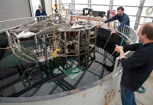
Norman Vine, Jonathan Howland, Hugh Popenoe (left to right), and Scott Gallager (not pictured) use a test tank in Gallager’s lab at WHOI's Environmental Systems Laboratory in May to calibrate the cameras on the HabCam benthic imaging system. (Photo by Tom Kleindinst, Woods Hole Oceanographic Institution)
CSA’s umbrella website, Zooniverse, has had approximately 700,000 volunteers contribute to data analysis, a number that increases by nearly 5,000 each week. With Seafloor Explorer, CSA says it will reach a new community of people and hopes, after analysis of the results by the scientists involved, to add another 150,000 images in the next year.
“We’re really led by the goals of the science team,” says Smith. “Over the next several months, we will look for the next opportunities.”
*Source: Woods Hole Oceanographic Institution